Until the 14th century there would now be three deer parks around Alnwick.
- Hulne Park and West Park spread to the north-west of Alnwick Castle, with Hulne Park to the north of the River Aln, and West Park next to it, south of the river.
- Cawledge Park lay to the south-east of the town.
In each, deer were contained by wooden palings.
Hulne Park and West Park would reach their most developed state as deer parks under Henry Algernon Percy, 5th Earl of Northumberland (1477-1527). He was known as “The Magnificent” because of his extravagant lifestyle. At the time of his death he owed £17,000 (about £17 million today). His pastimes were centred on his parks, and in 1513 he took an inventory. In Hulne Park and West Park he had 215 stags, 410 does and 199 fawns. By now Hulne Park was enclosed by a stone wall, said to be twenty miles in length. Hulne Park was described as well replenished with fallow deer, and well set with underwoods for cover and preservation of the deer. “a very stately park-like ground”. Part of the pale of the Hulne deer park can still be seen as a ditch and bank near Cloudy Crags, crossing the 19th century wall at an angle.
Neglect
The influence of the Percy family waned after the fifth earl. It recovered briefly under the seventh: until he was executed for his involvement in the Rising of the North. After dissolution, others acquired the site of Alnwick Abbey and Hulne Priory. As the fortunes of the Percys rose and fell, surveys recorded variations in the state of the parks. By the 1530s the number of deer in Hulne Park and West Park had fallen from 824 to 160 and the number in Cawledge Park had fallen from 618 to 100. Hulne Park and West Park were still partly protected by a wall and partly by a pale. Then a survey in 1570 found Hulne Park “well replenished with fallow deer and very well set with underwood in divers parts of the same for covert for the preservation of deer and for the most part enclosed with a stone wall and is in compass six miles”. West park was “for the most part enclosed with a stone wall”. Cawledge, though, was in poor condition: “in the same park are some deer but no great plenty by reason the pale is not repaired”. In 1586 there was still a full complement of park officers. Hulne Park and West Park were being managed separately, and the earl’s auditor reported that both were well maintained. By the end of the 16th century deer parks were falling into disuse, and the land was taking on a more commercial role.
By 1605 Cawledge was divided into five farms, but the Gunpowder Plot interrupted plans for the same to happen in Hulne Park. The ninth Earl was suspected of having some involvement, and was confined to the Tower of London and fined £30,000 (equivalent to £6million today). He needed to raise money so he commissioned Francis Mayson and Robert Norton to survey his properties. Hulne Park and Cawledge Park were surveyed in 1619 and the maps show both surrounded by paling.
By the end of the seventeenth century agricultural improvement was changing the local economy. Farming now accounted for almost half of the income from Hulne Park. Quarries, corn mills and fulling were also being developed. Agricultural improvement meant that mining coal became important, because it was needed to burn lime. But the Percy family saw little benefit from this economic development. They were absent landlords, rents were difficult to collect, and the way that the estate was managed had become antiquated.
All that changed when Sir Hugh Smithson and Elizabeth Seymour inherited her father’s estate in 1750.
1750 – 1786
The new earl brought experience of managing large estates, and political skill. Restoring the castle and improving the parkland was an effective way for him to establish his authority, stimulate the local economy, and hence earn support from the community. In 1756 the Earl and Countess asserted their rights as landowners, and brought a lawsuit against the town, but the changes they made to the boundary of their park were mostly in the area around Denwick. The lawsuit was concerned mainly with rights and practices, rather than boundaries. Agreement was reached in 1762, which attempted to clarify the rights of the different parties, while allowing established practices to continue. At that time the most significant change in relation to the perimeter of Hulne Park was when trees were planted at the South-West corner, on Brislee Hill. It is said that the Freemen were carrying out their annual ride of the boundary, when they got lost in the mist. The Duke’s agent took advantage of the mistake to appropriate 50 acres.
1786 – 1817
Until now, tenants whose land backed onto the boundary had been responsible for taking care of the perimeter wall, but there seems to have been little maintenance work, and its condition must have deteriorated. However, the second Duke had a military background, and a tidy mind. He was keen to get things straight.
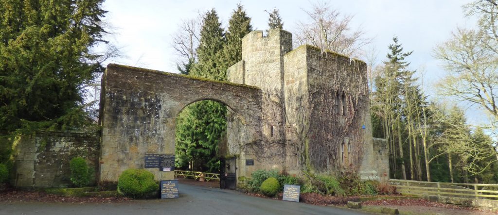
Around 1806, Hulne Park was expanded by the acquisition of more land. This included Alnwick Abbey, which the duke had demolished, retaining the gatehouse, as a new entrance to the park. He also extended the park to the west by adding Bassington Farm, and exchanged some land with the freemen at the Stocking Burn.
Following these changes, between 1806 and 1811, he had a perimeter wall constructed, to clearly define the new boundary of the park, and added lodges and gateways at the entrances. Inside the park carriage drives were extended, and bridges constructed over the River Aln. These schemes were implemented by estate workers, local masons, and David Stephenson, the Duke’s architect.
1817 – 1847
The third duke also added more land at Heckley, thereby extending the park to the east. However, the most dramatic boundary change arose from the opening of the Alnwick to Edlingham turnpike in 1826. The road to Eglingham passed through the park, and this compromised its privacy. When the Eglingham road was turnpiked, some 1,500 acres was cut off, and in 1827 a new wall was built along the turnpike.
There were still outstanding disagreements over the boundary of Alnwick Moor, but these were settled by the enclosure act in 1854. The valuer for the Enclosure Acts made an award for the enclosure of Alnwick Moor. The parish secured eight acres as a place of exercise and recreation, 237 acres were awarded to the Duke in compensation for rent due, and 54 acres was awarded to the freemen, to cover legal expenses.
1847 – present day
Once the Enclosure Act had settled the boundary, the duke planned a new entrance lodge and wall from Forest Lodge, to the Flagstaff on Cloudy Crags. The lodge at Stocking gate, named Forest Lodge, was designed by Anthony Salvin. The new wall would enclose the land that he had acquired as part of the settlement. But it would also block an ancient footway from Stoney Peth to Cloudy Crags. The duke offered to build the new wall six feet within his own land, so that there was room for a public footpath along the outside of the park to a high point on Cloudy Crags, which commanded fine views. The plan was welcomed by the Board of Health, but it does not seem to have been clear whether the Duke was proposing to provide the footpath, or just the land for one. By 1871 the wall was in place, but no path had been constructed, and the Board felt that the town had been deprived of access to an ancient footway, without gaining a new one.
Since then, there have been no significant changes to the perimeter of Hulne Park. Work on the wall has been in the nature of maintenance and repair. For example, on 3 November 1900, about forty yards of the walling were under-mined and washed down by a spate of water rushing into Shipley Burn. Between the wars, we hear that maintenance work was carried out under a job creation scheme for the unemployed. We would welcome further information on this.